Surbungtlang airport? Is that possible to build the airport in this mountainous Chin State? Is it a practical plan or just a speculation? or Just a proposal? or just making the news headline? Would the airport be beneficial for the economy of the Chin State?
I had traveled many places in the Chin State searching for a
place to build dams and airports. I saw only one place the so-called
, near Thantlang city that is
big and long enough to build an international airport. Unfortunately it is in
the deep valley of
and
is surrounded by high mountains such as Vankhamtlang in the East and
Vuichiptlang and Vanzangtlang in the west. It may be possible only for a small airplane to land in
that site only when the weather permits. It is not suitable site for the airport at all.
I also went to
Haithlan, a proposed airfield for the capital city of the Chin State, Hakha, near the Old Hakha. But it is obvious that it is not a suitable site for the airport at all. I also went to
Pawhtawnrawn a proposed airfield for
Thantlang. Neither airfields qualified to be the real airport. It will be very dangerous for the pilot during
monsoon season for landing in those sites.
There is a speculation that the site
near
Cengtum, near Gangaw city, was researched for the airfield for the Chin State. But it is too far for the Chin
State again. I did not have a chance to visit
Surbungtlang but some of my friends from
Falam told me about it when I was in Mandalay university. I am excited reading
the surprise news about Surbungtlang airport. Today, many of the works have been done. I am so eager to have an airport in the Chin State since I am a Chin. We all need to support this new airport for our Chin State.
 |
| Surbungtlang Airport during construction |
 |
| Road to Surbungtlang Airport |
 |
| Surbungtlang airport during construction |
 |
| Site of Surbungtlang Airport seen from away |
Surbungtlang Airport
is a new airport project near
Zathlir village,
Falam township, Chin State, Myanmar. It is in the middle of the northern Chin
State and can be reached easily from Thantlang, Hakha, Rihkhuadar and Falam
towns. It is about six miles from downtown Falam and is about 40 miles from
Hakha, the capital city of the Chin State. This new airport is scheduled to be
completed by 2016. Chin State is a very
mountainous region. It is not easy to find the site to build the airport. The
Surbungtlang airport will be the only
airport in the Northern Chin State and is amazing thing for the Chin people to have an
airfield in their own state (There was a small airport in Paletwa in the past
but it is not currently operational).
Surbungtlang airport would have advantages than other airports in Myanmar to connect direct flights to Aizawl, the capital of Mizoram and Imphal, the capital of Manipur and other cities in India and Bangladesh easier. It would directly boost tourism and other economy activities between India and Bangladesh. The location is pretty central for Hakha, Falam, Thantlang and Tiddim and it could be a commercial hub for the Chin State in the future too.
The three-day survey of the airport was done on October 24,
2012 by U Thant Zaw Moe from Myanmar Airline together with seven engineers and Mr.
Tin Naing Tun, Director General of the Transport Ministry's Civil Aviation
Deparment, Dr. Ngun San Aung, Chin State Transport Minister, Attorney Kap Tial
and several Hlutdaw representatives and some local leaders. According to the
survey the runway is about 10,000 feet long and 200 feet wide. This
Surbungtlang airfield served as a a temporary resupply airfield for the British forces
during World War II. The mountain is seven miles long and three miles wide.
Surbungtlang is situated at the heights of 6,352 feet
above sea level and its elevation will be the highest in Myanmar. Normally the
runway about 8,000 long and 200 feet wide is enough for domestic airport. The
British government probably did the survey in this area for airfield during
colony time. According Za Dunkk (Malaysia), "The survey was also done in
1975 when Pu Za Hre Lian was Chairman of
Pyithu
Council of the Chin State in that time. The weather experts from Mandalay
came to the site and measured the wind cross and direction. They concluded the
site was suitable for the airport because there was no wind-cross there that
may interfere the airplane landing and takeoff. Then they concluded the site is
the best place for airfield. The stone inscription also was found which was
laid by the British government which said "air-ground.
The British government asked the local leaders to build the airport in that
site but the local leaders rejected their idea because of their traditional
religious belief. Surbuntlang new airport project is a new project as part of
the agreement signed between the Chin National Front and the government of
Myanmar (
We, the Chin people, should be thankful to the CNF's movement regarding this new development of the airport). Surbuntlang airport will be big enough to land some big domestic
airplanes.
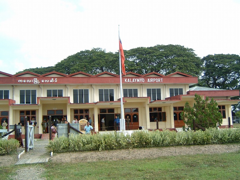 |
| Kalaymyo Airport |
Surbungtlang airport will be a midsize airfield comparison
with other nearby airfields such as
Lengpui
Airport in Mizoram which runway is about 8,200 feet long;
Kalaymyo Airport which is 6000 feet long; Myikyina airport
6,100 feet; Imphal Airport in Manipur 9,022 feet long. The runways of many
airports in Myanmar are less than 6,000 feet long. For example, the Lashio
airport is only 5,285 feet long. The runways of the international airports in
some countries are about 8,000-10,200 feet long.
 |
| Lengpui Airport |
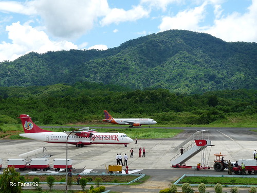 |
| Airplanes at Lengpui Airport, Mizoram |
For example, Port Columbus International
Airport, Ohio, has two runways for international flights-one is about 10,125 feet
long and another 8,000 feet long. Many large cargo and passenger planes landed
in that field. Paro International Airport, the only international airport of Bhutan, is situated in the river valley at the heights of 7,300 feet above sea level, which has only a single 6,445 feet asphalt runway. It is surrounded by 18,000 feet high mountains. It is one of the most dangerous and challenging airports in the world.
 |
| Paro Airport |
Comparison with this
Paro International Airport Surbungtlang airport may be big enough to land midsize
planes and could be upgraded to an international airport if it has 10,000 feet asphalt runway. Some experts who visited the Surbungtlang said that the wind direction and speed also permits the site is suitable for the airport. Paro Airport is surrounded by very high mountains but some big airplanes land and take off from it. There is no doubt that Surbungtlang airport is suitable for midsize airplanes to land.
 |
| Falam Town |
Surbungtlang airport will boost the economy of the old capital city of the Chin Special Division, Falam town which has about 15,000 people and
the surrounding villages, if the project is implemented. Falam is a very beautiful city and most of its streets were widened and modernized recently. The airport will also make a better
communication between the Chin State and the mainland Myanmar. It will also
help the security of Myanmar air space since the airfield is near the Indian
border. It will also promote the industry of tourism in the northern Chin
State.
Rih Lake already boosts the
economy of the surrounding villages in many ways in the past.
There are some other tourist destinations near Surbungtlang
airfield such as a historial Lailun Cave, Laikua Dam, popular Zinghmuh
Mountain, Simpi Village which is the first Lai settlement village when the
forefathers of the Chin people entered the present Chin State. Falam is a
historical town because the British government administration center was in
that city. Runva (Manipur River), one of the largest rivers in the Chin State,
is a perfect place for rafting for the adventurers. Therefore if Surbungtlang airport is built
it will boost the economy of the Chin people and Chin state government.
-------------------------------------------------------------------------------
Reference


No comments:
Post a Comment